Russia Develops GPS-Free Navigation System for Lightweight Drones
The new alternative navigation platform is designed to enable unmanned aircraft to operate without satellite signals.
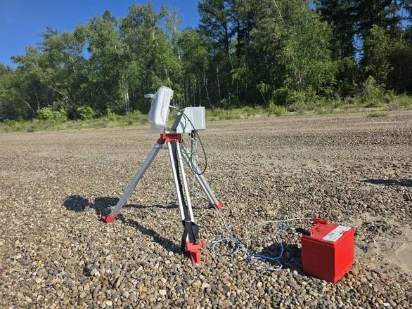
Russia has unveiled its first alternative navigation system, known as MANS, built specifically for lightweight drones. The system allows unmanned aircraft to fly without relying on GPS or GLONASS signals. It does not require high-performance onboard computers, a factor developers say reduces costs and could support broader adoption, according to Izvestia.
The modular platform is designed from the outset for compact drones and affordable computing hardware. It runs on low-power single-board computers built on ARM architecture, reducing strain on a drone’s battery. Flight endurance remains comparable to aircraft equipped with satellite navigation.
The drone determines its position using two modules—optical and inertial. The system can operate with microelectromechanical sensors or with a mechanical gyroscope module developed by the project’s engineers. It also incorporates data from an onboard camera, matching imagery with terrain maps or analyzing visual input without reference to specific landmarks.
What MANS Is Designed to Do
Yury Molodykh, director of the Technology Competition Development Center at the NTI Foundation’s Up Great initiative, said the system enables fully autonomous navigation for unmanned aerial vehicles. Existing solutions typically require external infrastructure, such as beacons or signal repeaters, to support navigation. The new platform operates solely using onboard equipment.
Nikolai Ryashin, CEO of Rusdroneport and an expert in the NTI Aeronet market segment, described the development as in demand for the drone aviation industry. Navigation technologies that do not depend on satellite links are needed for a broad range of applied tasks, he said.
The system is intended for terrain monitoring and can also be used in agriculture. It is capable of navigation even without preloaded area maps, allowing deployment in new or hard-to-access locations. At altitudes above 300 meters, the system can additionally integrate data from satellite maps.
MANS has already been tested in environments without satellite navigation and is being prepared for deployment. Final acceptance trials are scheduled for the first quarter of 2026.
Earlier, we reported that Russian engineers are developing robots capable of operating underwater without navigation signals, enabling them to see and orient themselves without satellite support.